

You can find on this page the Tel Aviv trains map to print and to download in PDF. The Tel Aviv trains map presents the rail network and railway stations of the trains of Tel Aviv in Israel.
The Tel Aviv rails map shows all the railway stations and lines of Tel Aviv trains. This railway map of Tel Aviv will allow you to easily plan your route with the trains of Tel Aviv in Israel. The Tel Aviv rails map is downloadable in PDF, printable and free.
Tel Aviv has four train stations along the Ayalon Highway. The stops are from north to south: Tel Aviv University , Tel Aviv Savidor Central , Tel Aviv HaShalom (near Azrieli Center shopping mall) and Tel Aviv HaHagana (near the central bus station ) as you can see in Tel Aviv rail map. It is estimated that more than a million people travel by train from the surrounding cities to Tel Aviv each month. Since the completion of the Ayalon Highway railway section in 1995, Tel Aviv has been the central hub for rail transport in Israel. The Savidor Central Railway Station alone handled approximately 38,000 passengers a day in summer 2009. Railway lines from Tel Aviv include Israel Railways main line, running from Beersheba to Nahariya , as well as lines to Ashkelon , Modi'in , Rishon LeTziyon , Kfar Sava and Jerusalem . A faster line to Ashkelon via Bat Yam / Holonis under construction. Most trains stop at all stations in Tel Aviv, except for some trains to and from Be'er Sheva that do not reach Tel Aviv University and night trains that only stop at Tel Aviv Savidor Central. All stations of Israel Railways, other than Dimona, are directly reachable from Tel Aviv.
Israel Railways runs train services within Israel. Over the last decade, train service has improved considerably throughout the country. Today, trains are a fast and comfortable alternative to buses for many destinations. Train routes connect Tel Aviv-Yafo to Haifa and Be'er-Sheva, as well as to numerous smaller towns and to Ben-Gurion airport as its shown in Tel Aviv rail map. Tel Aviv-Yafo has four train stations, all of which are located along the Ayalon Highway. All trains to Tel Aviv-Yafo stop in all four stations. For best access to the city center, use either "Tel Aviv Merkaz" (also known as Arlozorov), or "Hashalom" (located in a large shopping mall). "Tel Aviv Hahagana" Station is close to the New Central Bus Station, though most inter and intra city buses also leave from the terminal outside "Tel Aviv Merkaz" ("Arlozorov") train station.
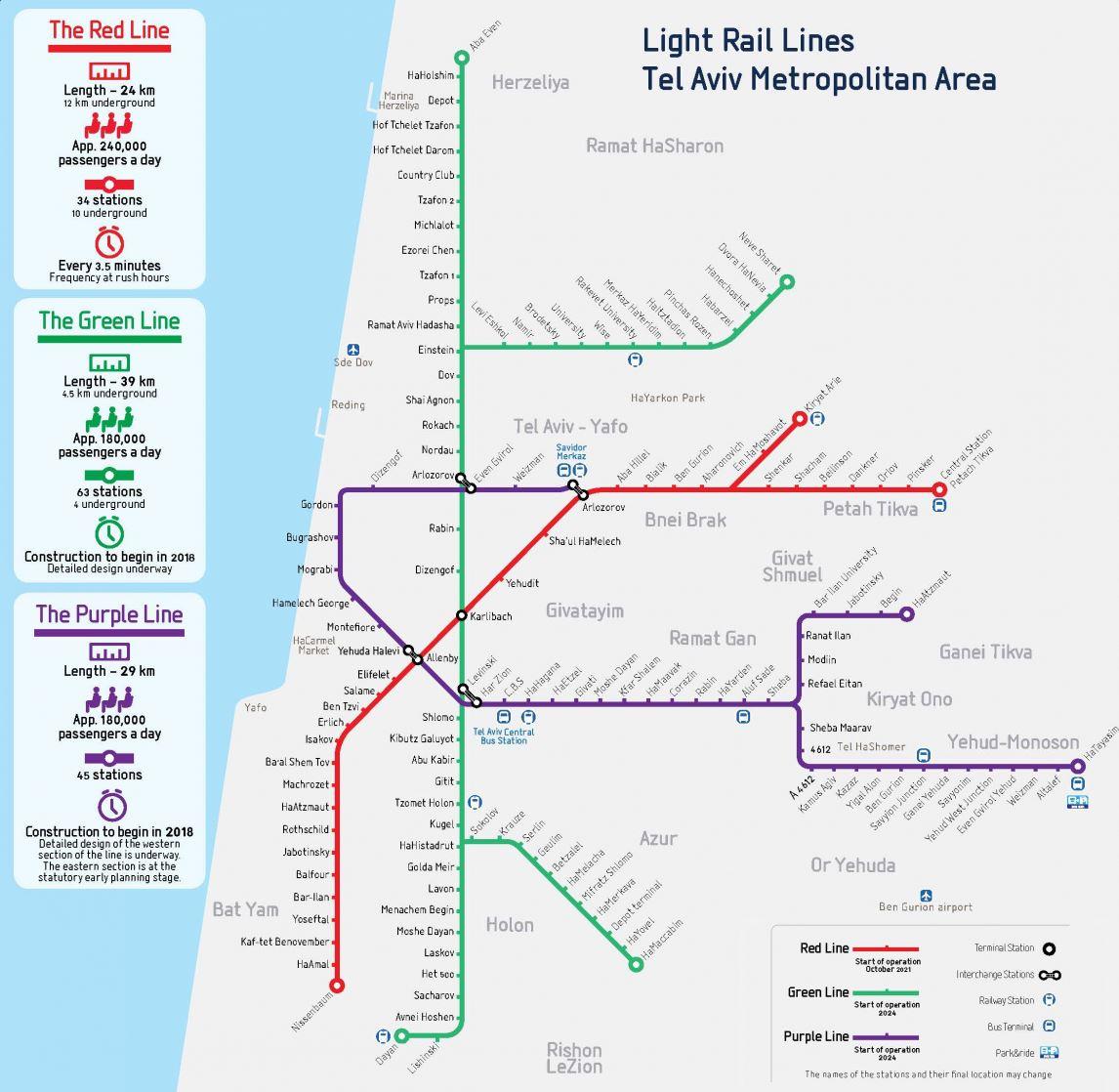
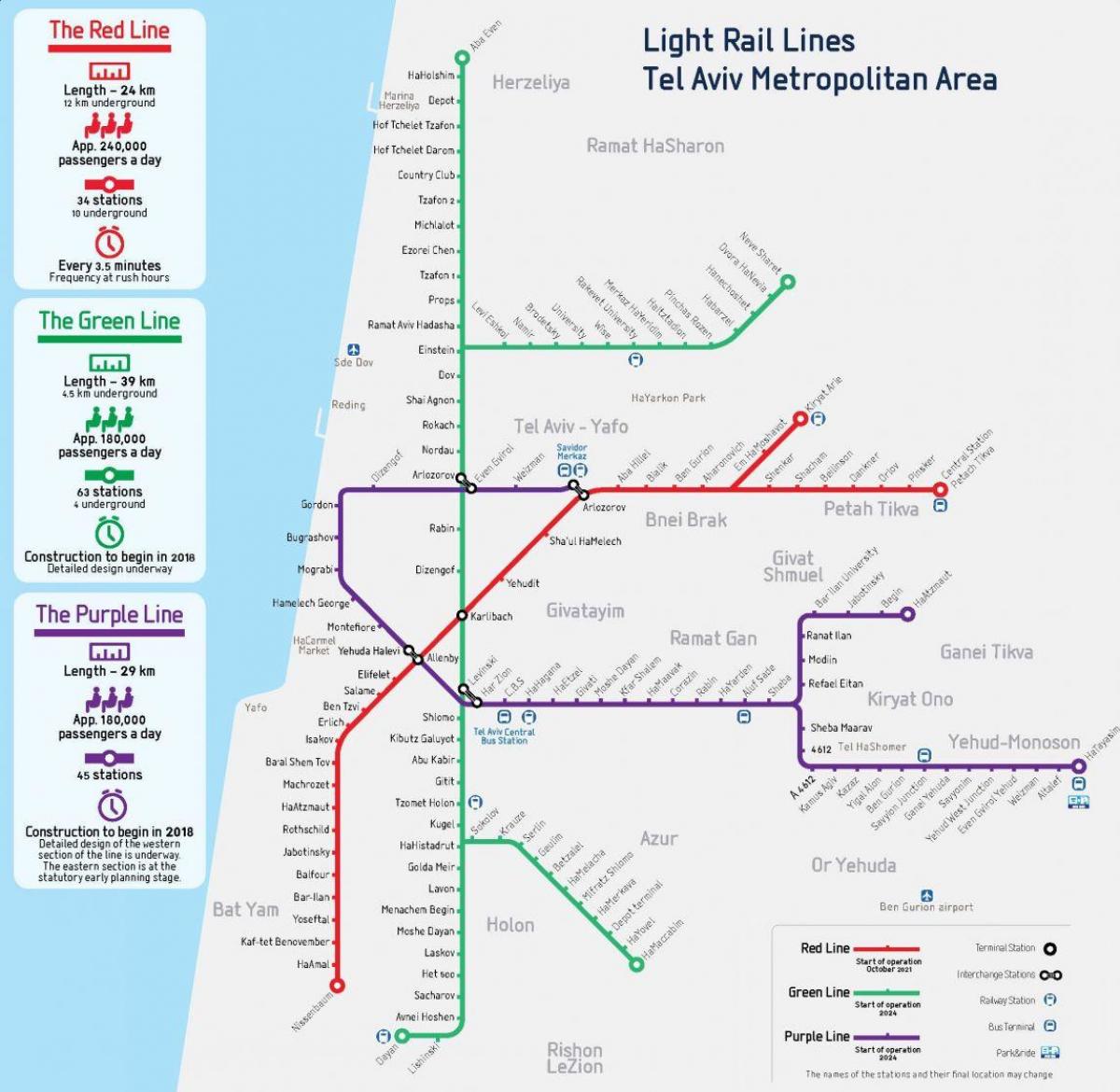
The Tel Aviv Metropolitan light rail system underwent its first test following six years of work on early Thursday morning, when two trains made their way from Petah Tikva to Bat Yam via Jaffa Jerusalem Boulevard as its mentioned in Tel Aviv rail map. The 24-kilometer journey was the first time that trains operated on the NTA Metropolitan Mass Transit System Red Line, which will be one of four operating in the Tel Aviv-Jaffa metropolitan area starting in 2023. According to the NTA, the Red Line “will be the ‘backbone’ of the mass transit system, and will pass through the most congested regions of the metropolitan area, serving the greatest number of passengers when compared with future lines to be constructed in the framework of NTA transit vision.” Trains on the line, which will be partially underground, are slated to run approximately every three minutes.