

You can find on this page the Tel Aviv metro map to print and to download in PDF. The Tel Aviv metro map presents the network, zones, stations and different lines of the metro of Tel Aviv in Israel.
The Tel Aviv metro map shows all the stations and lines of the Tel Aviv metro. This metro map of Tel Aviv will allow you to easily plan your routes in the metro of Tel Aviv in Israel. The Tel Aviv metro map is downloadable in PDF, printable and free.
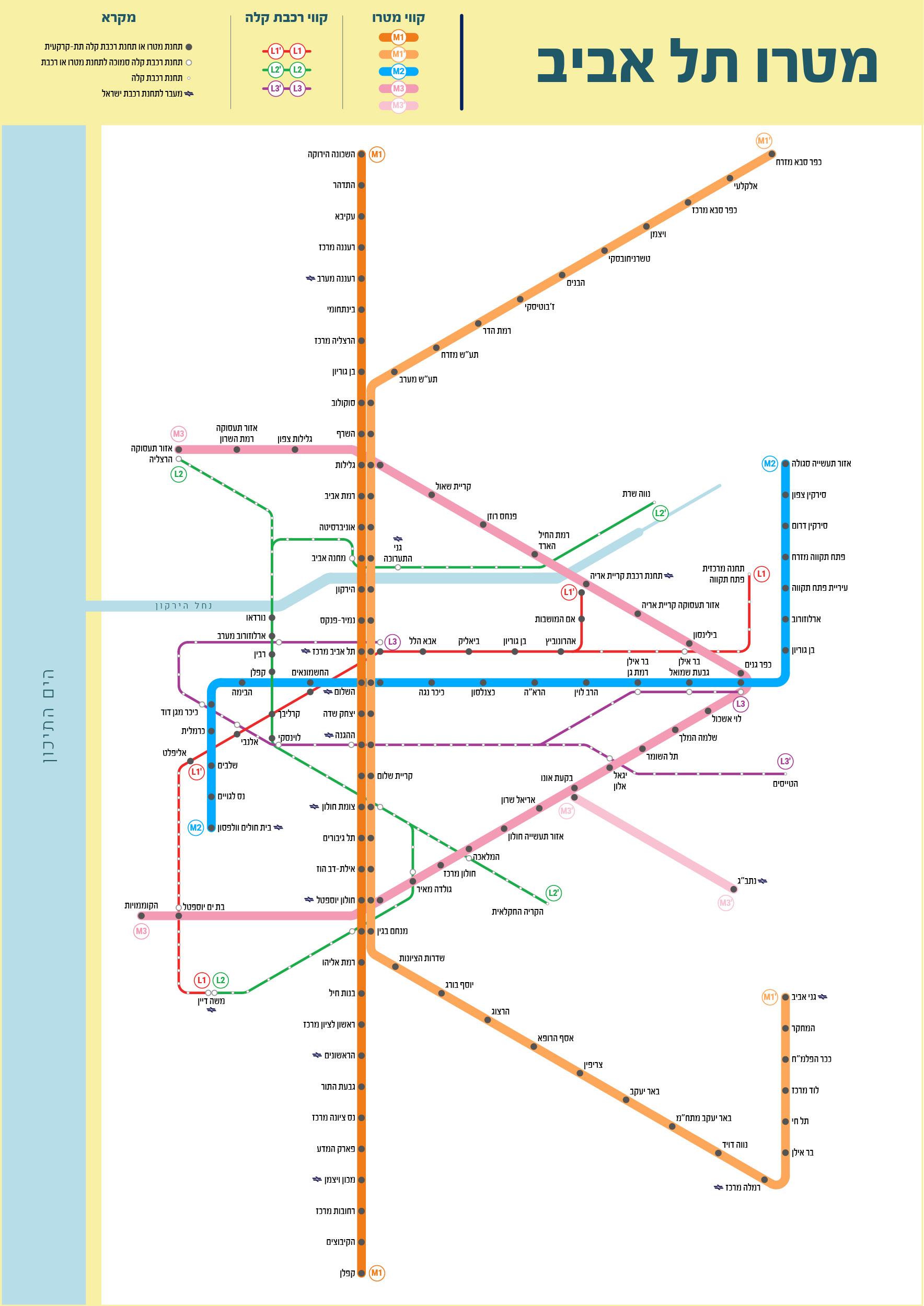
Tel Aviv metro line network includes 3 lines with a total length of 150 km Underground network that will serve the Tel Aviv metropolitan area through 109 stations as you can see in Metro map Tel Aviv. 4 Depot complexes are designed to support the network. The Objective is to establish a mass transit system that links commuter towns to the center of the Tel Aviv Metropolitan Area and its major business centers, quickly and conveniently, and connecting residential neighborhoods with workplaces via light rail, heavy rail, and other public transport.
Tel Aviv metro line – M1 as its shown in Metro map Tel Aviv: is a radial line connecting the Northern and Southern municipalities to the center of Tel Aviv. The line is divided into 2 statutory plans - one for the northern section and the other for the southern section. The line is designed for Connecting the northern and southern regions of the metropolis to the employment and trade centers in Tel Aviv city. It also serves as the backbone of the metro network (along the Ayalon Road) on which the entire network is based.
Tel Aviv metro Line – M2: is a radial line connecting the East cities of the Metropolitan to the center of Tel-Aviv. The line is connecting the eastern regions of the metropolis to central and southern city of Tel Aviv. The construction of the line includes an engineering challenge because it crosses the crowded areas in downtown Tel Aviv. Metro Line – M3 as its mentioned in Metro map Tel Aviv: is a half-ring line connecting all lines and creating an integrative network. This line is designed for accessibility and connectivity to significant employment centers on the metropolitan inner ring border. It creates connectivity in the future metropolitan transportation network.

The Tel Aviv subway map shows all the stations and lines of the Tel Aviv subway. This subway map of Tel Aviv will allow you to easily plan your routes in the subway of Tel Aviv en Israel. The Tel Aviv subway map is downloadable in PDF, printable and free.
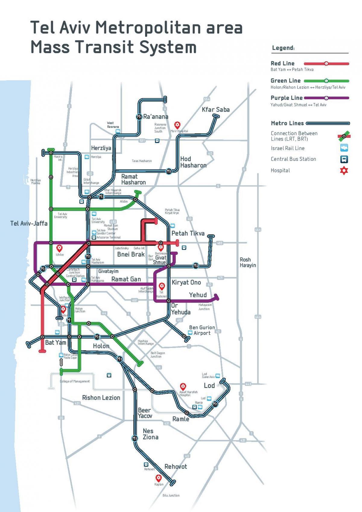
The Tel Aviv Metropolitan Area Mass-Transit System is a long planned mass transit system for the Tel Aviv Metropolitan Area as you can see in Tel Aviv subway map. The system will include different types of rapid transit like light rail (which will run underground in some areas), bus and more. Work on the Red Line, the first in the project, started on September 21, 2011, following years of preparatory works and numerous delays. A subway system was first planned in the mid-1960s, and in 1967 a station at the Shalom Meir Tower was inaugurated in the presence of then Prime Minister Levi Eshkol. However, financial difficulties forced the abandonment of the project, and Shalom Meir remains the only subway station in Tel Aviv, disconnected from other transport links.
Tel Aviv subway blueprint includes eight lines: two in planning stages, one under approval, one under construction, and four more planned for the future. The first four lines will cover 100 km (62 mi) around the Tel Aviv metropolitan area, with future plans to BRT lines and feeders in addition as its shown in Tel Aviv subway map. About 10 kilometres (6 mi) of the 22 kilometres (14 mi) Red Line is to be built underground, with the remaining overground segment constructed in as a light rail/tram. It is to have 33 stops, 10 of which would be underground, with an average distance of 500 metres between them. The average distance between the overground stops would be 1 km. The line would run from Bat Yam in the southwest, through Jaffa and central Tel Aviv, and carry on to Petah Tikva, through Ramat Gan and Bnei Brak. An interchange is planned for Tel Aviv Central railway station. It has been forecast that by 2020, 100 million people would be using this line annually.
The second or Green Line of Tel Aviv subway, in the approval phase, is a 35 kilometres (22 mi) line with 58 stops that would run from the west of Rishon LeZion northwards through Holon through central Tel Aviv and will split into two branches: One to Herzliya in the north, and one to Ramat HaHayal neighbrhood in Tel Aviv in the northeast as its mentioned in Tel Aviv subway map. The third, or Purple Line, also in the planning phase, is envisaged as a 36 kilometres (22 mi) line with 56 stops and will connect Petah Tikva Sgula to Sheba Hospital through Giv'at Shmuel and Kiryat Ono, and will connect Arlozorov in Tel Aviv to Yehud and Or Yehuda through Ramat Gan. There are considerations to make the central part of the line (From Sheba Hospital to Arlozorov) underground.