

You can find on this page the Tel Aviv neighborhood map to print and to download in PDF. The Tel Aviv districts map presents quarters, region, suburbs and surrounding area of Tel Aviv in Israel.
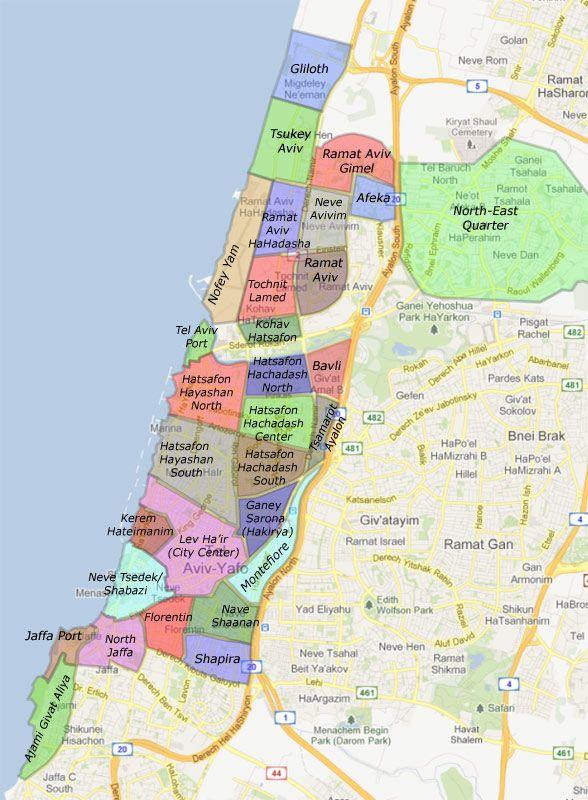
The Tel Aviv neighborhoods map shows region and suburbs of Tel Aviv areas. This neighborhood map of Tel Aviv will allow you to discover quarters and surrounding area of Tel Aviv in Israel. The Tel Aviv quarters map is downloadable in PDF, printable and free.
At the heart of Sarona neighborhood lies the shopping and recreation center, Sarona Colony - a site which was originally a German Templar Colony and later on housed the first government offices of the State of Israel. Nearby is HaHashmona'im Street, home to the TLV Fashion Mall and HaArba'a Street, known for its chef restaurants and highly acclaimed Cinematheque as you can see in Tel Aviv neighborhoods map. Hayarkon neighborhood encompasses the Tel Aviv Port, HaYarkon Park (Ganne Yehoshua), and the city northern residential areas. The port serves as a popular center for shopping and recreation while the spacious park is the city green oasis. The residential areas in this district are family-oriented, offering a quiet atmosphere not far from the bustling city center.
Nave Sha’nan, located near the Tel Aviv Central Bus Station, was founded in the 1920. With the years, it became a melting pot of cultures and ethnicities, holding a complex reality. It is recommended to take a guided tour to learn about the stories and people behind this neighborhood. Stretching from the northern Ben-Gurion Boulevard to the southern Gan HaHashmal neighborhood, Tel Aviv White City (“Bauhaus” architecture) features the world largest collection of international style buildings. Constructed in the 1930 by German immigrants who belonged to the Bauhaus movement, these historic buildings are characterized by their functionality and simplicity. Neve Tsedek as its shown in Tel Aviv neighborhoods map, one of the first Jewish neighborhoods to be built outside of Jaffa, is a trendy area full of shops, art galleries, and stylish restaurants. You can also find here the Suzanne Dellal Center which hosts highly acclaimed dance performances.
Florentin is often referred to as the hipster neighborhood of Tel Aviv. In the past, the area was underdeveloped. However, in the 90 it attracted an artsy crowd due to its low prices and loft-style buildings. Today it is home to musicians, designers, photographers, and more. Take in the laid-back and creative atmosphere as you explore Florentin colorful street art and alternative nightlife scene. HaTikva as its mentioned in Tel Aviv neighborhoods map, located in southern Tel Aviv, offers an authentic local experience. At the heart of this neighborhood lies HaTikva Market, a place full of cheap produce and Yemeni, Moroccan, and Iraqi style restaurants. In recent years, the neighborhood has seen a growth in its number of young residents, sparking the establishment of new businesses. Old Jaffa is one of the most ancient port cities in the world. It is full of historical sites, restaurants, and intrigue. From attractions that backtrack through years of ancient history to a laid-back, yet vibrant nightlife scene, Jaffa offers a range of attractions including mosques and churches, ancient clock towers.

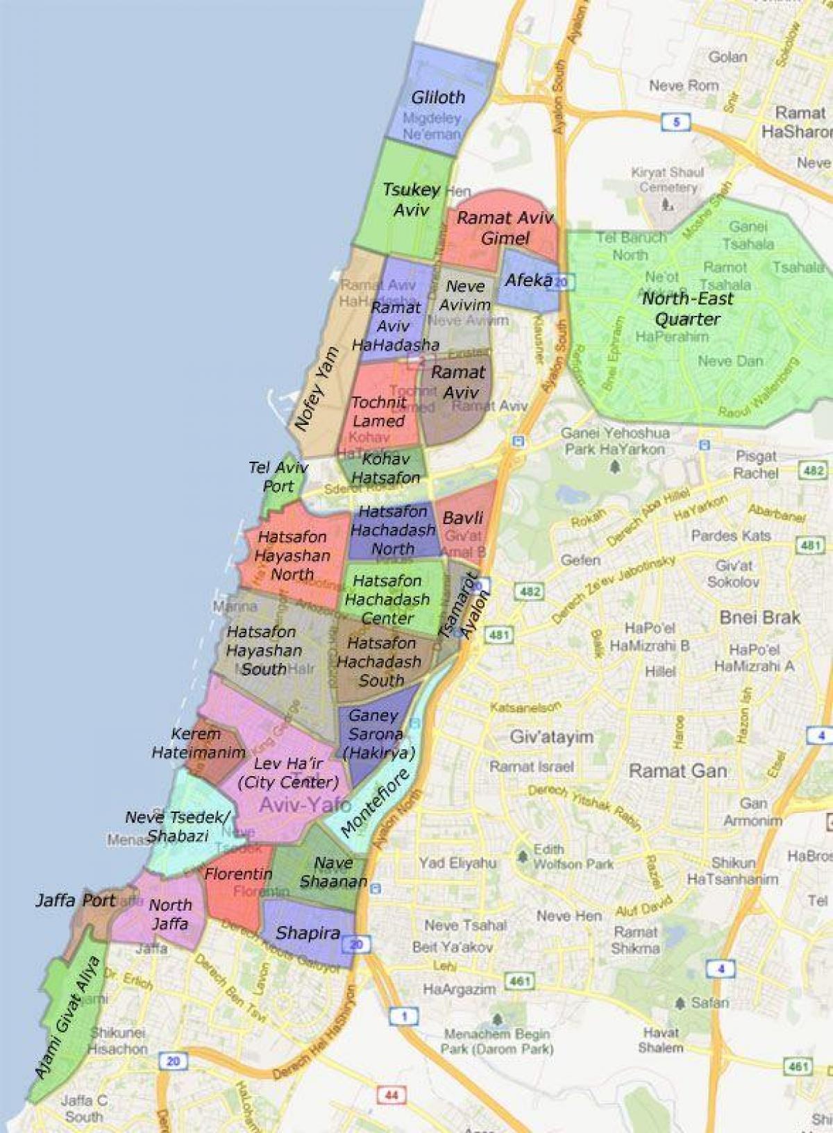
The Tel Aviv districts map shows all quarters and suburbs of Tel Aviv. This district map of Tel Aviv will allow you to discover areas and the region of Tel Aviv in Israel. The Tel Aviv districts map is downloadable in PDF, printable and free.
Tel Aviv is divided into nine districts that have formed naturally over the city short history as you can see in Tel Aviv districts map. The oldest of these is Jaffa, the ancient port city out of which Tel Aviv grew. This area is traditionally made up demographically of a greater percentage of Arabs, but recent gentrification is replacing them with a young professional and artist population. Similar processes are occurring in nearby Neve Tzedek, the original Jewish neighborhood outside of Jaffa. Right on the beach district there are a lot of hotels. Actually, the promenade is not an own district, as it extends over several. But in order to understand the city, as it is very similar along the whole coast. If your hotel is located here, you have the perfect location to enjoy the beach directly in the morning. During the day, the beach is also a great starting point to get anywhere in the city.
Ramat Aviv as its mentioned in Tel Aviv districts map, a district in the northern part of the city that is largely made up of luxury apartments and includes Tel Aviv University, is currently undergoing extensive expansion and is set to absorb the beachfront property of Sde Dov Airport after its decommissioning. The area known as HaKirya is the Israel Defense Forces (IDF) headquarters and a large military base. Historically, there was a demographic split between the Ashkenazi northern side of the city, including the district of Ramat Aviv, and the southern, more Sephardi and Mizrahi neighborhoods including Neve Tzedek and Florentin. The centre of Old North, the district that as the name suggests is all the way to the north, is the lively harbour of Tel Aviv. There are some bistros with Mediterranean cuisine, a few bars and two clubs. The main shopping street at the harbour is full of known fashion boutiques.
Florentin is the up-and-coming district with a hipster atmosphere. You will find many unconventional cafes, cosy bars and live music. Levinsky Market is also in this area, where you can go for a relatively cheap lunch. There are stalls with Börek and Falafel as well as numerous spice merchants. Often the district or its change in the last year is compared to what happened with the New York Soho district. Other districts, such as Sarona, have been developed with office towers. Central Tel Aviv is home to Azrieli Center and the important financial and commerce district along Ayalon Highway as its shown in Tel Aviv districts map.