

You can find on this page the Tel Aviv streets map to print and to download in PDF. The Tel Aviv roads map presents the road network, main roads, routes and motorways of Tel Aviv in Israel.
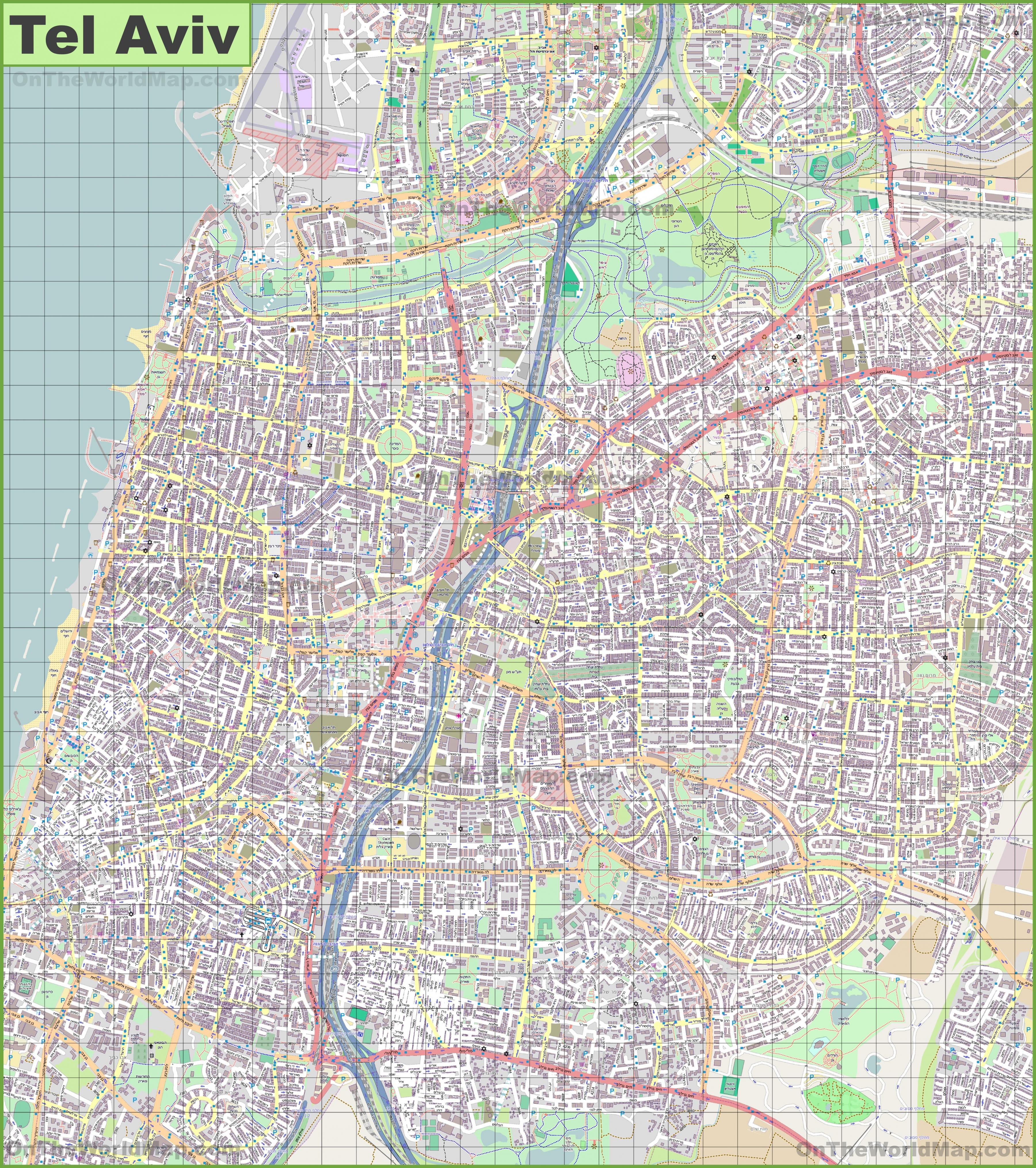
The Tel Aviv streets map shows all street network and main roads of Tel Aviv. This streets map of Tel Aviv will allow you to find your routes through the streets of Tel Aviv in Israel. The Tel Aviv streets map is downloadable in PDF, printable and free.
Bograshov is a busy street that stretches from the corner of King George Street and Ben Zion Boulevard in the center of Tel Aviv to the Bograshov beach in the west as you can see in Tel Aviv streets map. It was built in 1922-1923 and named after Haim Bograshov, a Zionist activist and one of the main founders of “Gymnasia-Herzliya”. It is home for some of the trendiest shops around and if you’re looking for a nice t-shirt, cool sneakers or even surf clothing this is the place you should go to. Basel street is where Tel Aviv high society comes to drink its coffee. It connects Dizengoff and Ibn Gabirol streets but has nothing to do with their chaotic atmosphere. When talking about Basel, most people refer to the part between Sokolov street in the west and Yehoshua Bin Nun in the east which is called “The Basel Compound”.
Two whimsical, curious and lovely little alleys (Simta is the Hebrew equivalent for alley) just off King George Street that go by the funny names of Almonit (Anonymous) and Plonit (unidentified or nameless) as its shown in Tel Aviv streets map. It all started with a dispute over their names between Meir Dizengoff (the first mayor of Tel Aviv) and Meir Getzel Shapiro (a wealthy businessman and their founder) who wanted to name them after himself and his wife. Dizengoff refused and decided to temporarily name them Almonit and Plonit. Najara is the gateway to Kerem Hateimanim neighborhood. You take a left turn from Allenby Street (if you’re facing the sea) and get inside the “backstage” of the Carmel Market- great little eateries, local bars and beautiful architecture that blends with the scenery.
Nakhmani Street is one of the most beautiful streets of Tel Aviv, situated right in the heart of the city, and at the same time exudes a peaceful and quiet atmosphere. At the center of the street you will find the King Albert Square (named after Albert the First, king of the Belgians, who was a close friend of Meir Dizengoff and was killed in a mountaineering accident) and the Pagoda House, a beautiful building that combines modern and oriental influences as its mentioned in Tel Aviv streets map. Herzl Street is the ultimate mix of old meets new. Named after Binyamin Ze’ev Herzl the “visionary of the state of Israel”, Herzl Street is the main street of “Ahuzat Bayit” the group that formed the foundation to the first Hebrew city in Israel. You can find furniture stores along old and quirky shops and stylish boutiques.

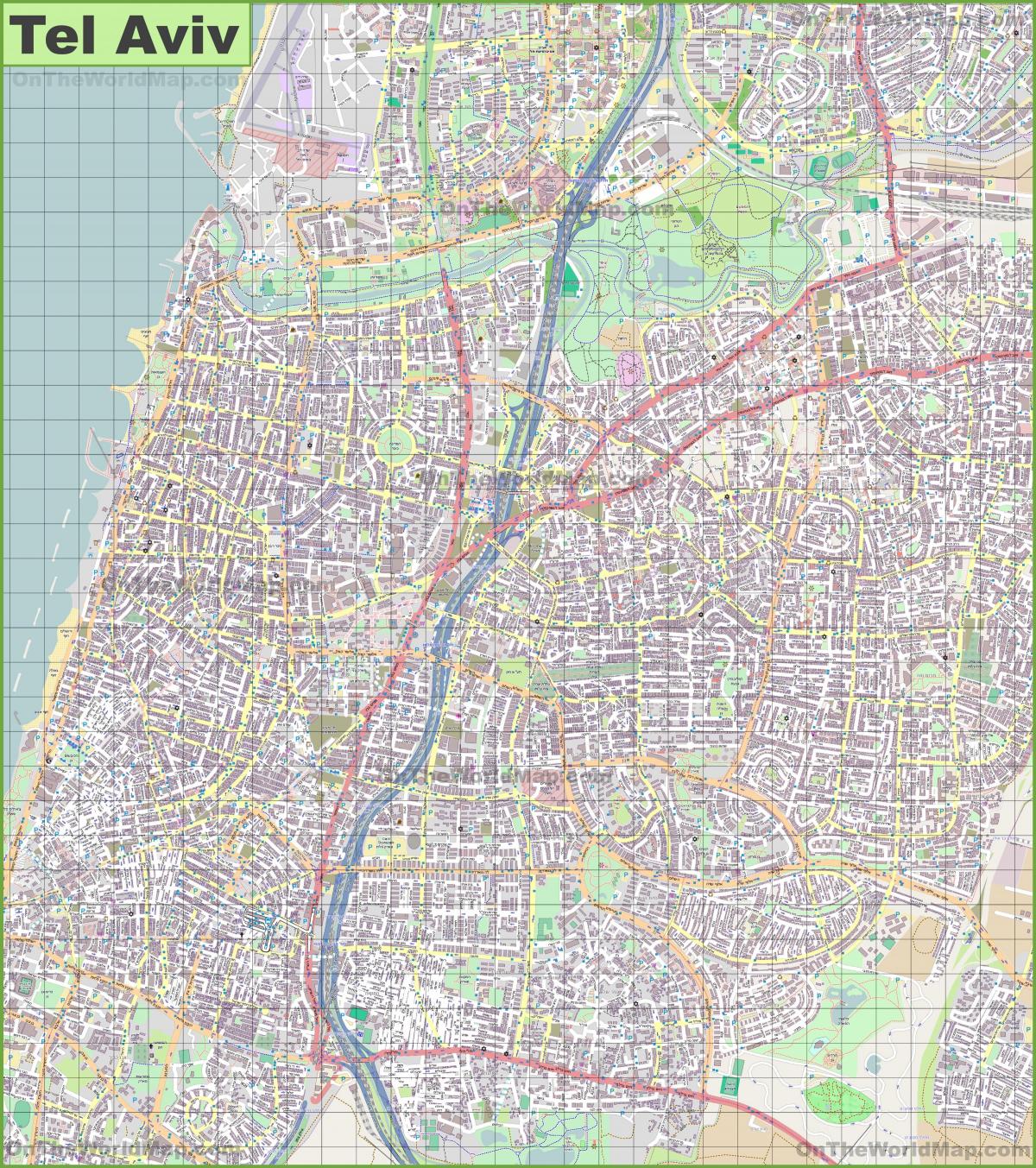
The Tel Aviv roads map shows all road network and highways of Tel Aviv. This roads map of Tel Aviv will allow you to find your routes through the roads and motorways of Tel Aviv in Israel. The Tel Aviv roads map is downloadable in PDF, printable and free.
The main highway leading to the city is the Ayalon Highway (Highway 20), which runs along the eastern side of the city from north to south along the Ayalon River riverbed, dividing for the most part Tel Aviv and Ramat Gan as you can see in Tel Aviv roads map. Driving south on the Ayalon gives access to Highway 1, leading to Ben Gurion International Airport and Jerusalem. Within the city, main routes include Kaplan Street, Allenby Street, Ibn Gabirol Street, Dizengoff Street, Rothschild Boulevard, and in Jaffa the main route is Jerusalem Boulevard.
Namir Road connects the city to Highway 2, Israel main north–south highway, and Begin/Jabotinsky Road, which provides access from the east through Ramat Gan, Bnei Brak and Petah Tikva as its shown in Tel Aviv roads map. Tel Aviv, accommodating about 500,000 commuter cars daily, suffers from increasing congestion. In 2007, the Sadan Report recommended the introduction of a congestion charge similar to that of London in Tel Aviv as well as other Israeli cities. Under this plan, road users traveling into the city would pay a fixed fee.
Highway 20 , more commonly the Ayalon Highway ( Hebrew : נתיבי איילון , pronounced: "Netivei Ayalon" , lit. "Ayalon Routes"), is a major intracity freeway in Gush Dan, Israel. The road runs along Tel Aviv center eastern border from north to south (with a planned east-west branch as well) and connects all of the major highways leading to the city — such as Highway 4 from Ashdod and the Southern regions , Highway 2 from Haifa and theNorthern regions , Highway 5 from the East, and Highway 1 from Jerusalem and the Southeast as its mentioned in Tel Aviv roads map. The Ayalon Highway is heavily traveled and on an average day almost 600,000 vehicles enter the freeway. It consists of a multi-lane highway with a multi-track railway located between the opposite travel lanes. Some of the highway route is along the Ayalon River, hence its name.